No, no, not another geography lesson! I promise, it’s not intended to be. It’s just that I’ve spent the past week installing an upgrade for this website, including a little thumbnail map on the home page. This post is simply to give the full-size map a home and to give credit to the source: freeworldmaps.net. (Let me also point out that I realize I’ve ended this post title, and others, with a preposition. “Where We Are” may be more correct but just doesn’t have the same ring to it, if you ask me! Besides, I have to pay homage to my Kansas roots every once in a while…)

I love this map! It’s a little bit artsy, and in nice earthy colors; it’s the right size and proportion to make a decent thumbnail, with only the countries and capitals labeled; and it’s one of the few maps out there, believe it or not, that includes the world’s newest country, South Sudan. (Obviously, I added the star and arrowed text on this version. Nigeria and South Africa are common points of reference-slash-confusion, and I threw in “the other Congo” for a chuckle.)
While we’re on the subject of geography… let me sneak in a little something extra. (Oops! But I promised!) In a couple of earlier posts I made reference to the massive size of the continent, specifically how the entire continental U.S. could fit inside the Sahara Desert. A picture’s worth a thousand words, right?
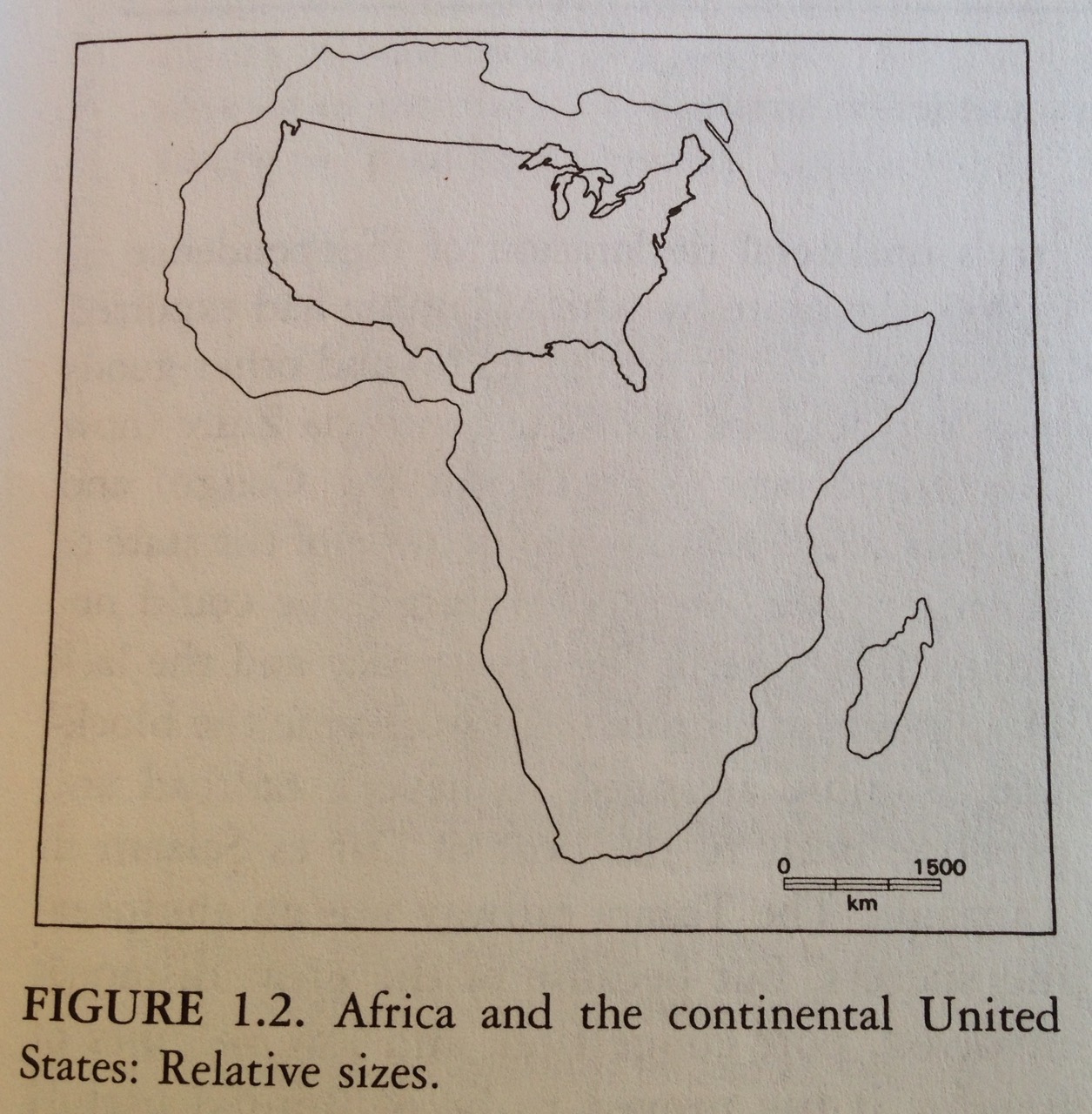
This image comes from “Africa South of the Sahara: A Geographical Interpretation,” a textbook we used at Thunderbird by Robert Stock, Guilford Press 2004. The Canadian author makes an argument that African issues are underrepresented in the Western consciousness partially because we think of it as a smaller place than it actually as. But not entirely due to ethnocentrism — it doesn’t help that we’ve been using the wrong maps. “Because distortion within a Mercator projection [the flat world-atlas style maps we use in schools] increases markedly with distance from the equator, places at higher latitudes, such as Greenland and Canada, appear much larger than places of comparable size nearer the equator. For example, although Greenland appears to be roughly the same size as Africa on a Mercator projection, it is actually only 7.3% as large, or slightly smaller than the Democratic Republic of the Congo.”
Greenland the same size as Africa versus smaller than the DRC is a big difference. No wonder we’re all totally confused.
For a less textbooky version of this same concept but with lovelier images and a funny story, see kai.subblue.com.
All right, geography lesson done. I PROMISE.
I hope you like the upgrade. I tried to make the look and feel of the whole site simpler and better organized. Also, I had noticed the auto-hyphenation of words at the end of a line was sometimes strange and irregular; the people at WordPress helped me set up some custom code to eliminate that problem. And there’s a new, shorter address: simply adventuresincongo.com. You might say, we’re on the map!

Nothing beat Goode Homolosine!
http://xkcd.com/977/
LikeLike
Except maybe a better name!
LikeLike
I vote for Winkel-Tripel, simply based on the name alone, although the Waterman Butterfly is a close second!
LikeLike